
MARS
Links
- NASA JPL

50 Years ago today. Spend a moment and consider the scale of this human endeavour.
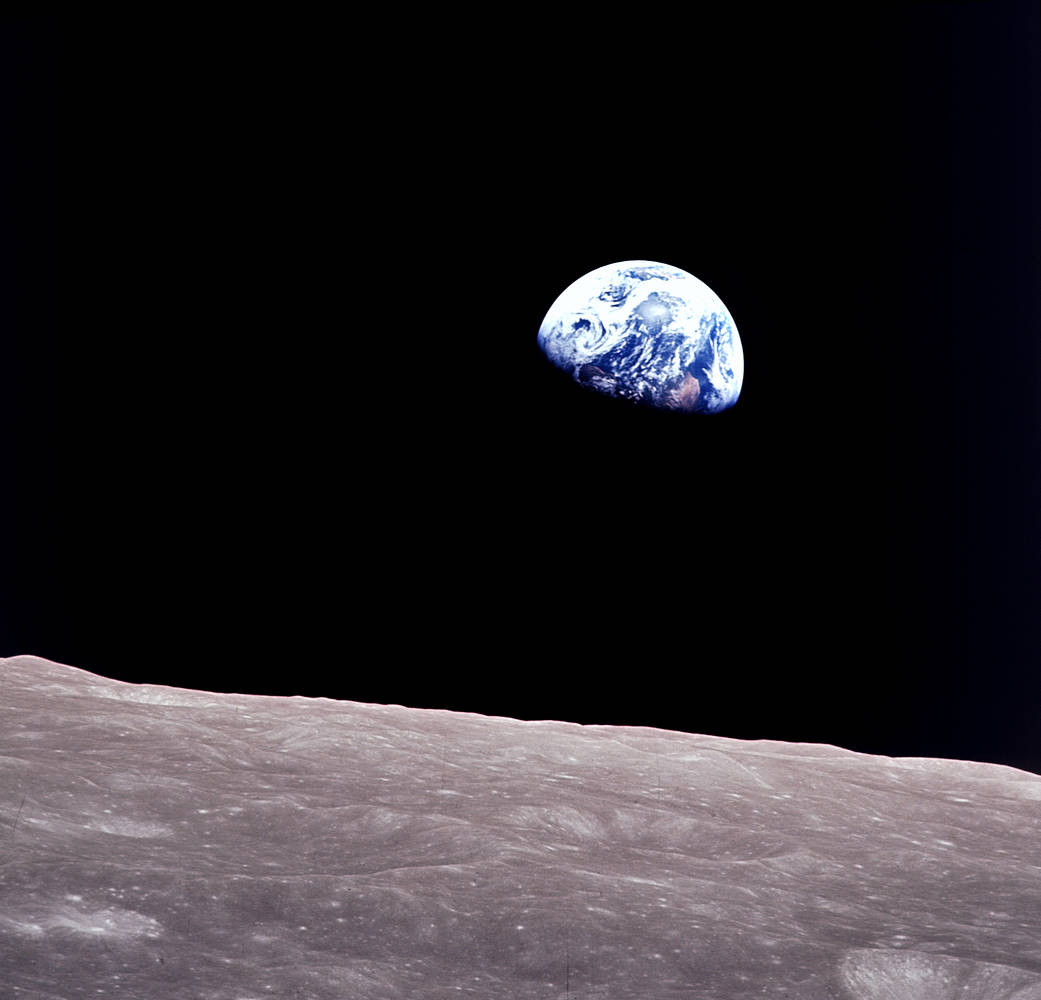
Seems like yesterday.
69 hours, 8 minutes and 16 seconds after launch, the crew reached the far side of the Moon. They burned their engines for a lunar orbit insertion (LOI), which lasted four minutes. The burn slowed the spacecraft down so it could be captured by the Moon’s gravitational pull, making it the first ever manned satellite of another world.
The Moon is tidally locked to Earth, which means it rotates on its axis at the exact same rate that it orbits Earth. As a result, we only see one side of the Moon from Earth’s surface. Borman, Lovell and Anders were the first to see the far side…
Lovell described it during a live telecast as,
“essentially gray, no color…like Plaster of Paris or some sort of grayish beach sand.”


For the second time in history, a human-made object has reached the space between the stars. NASA’s Voyager 2 probe now has exited the heliosphere – the protective bubble of particles and magnetic fields created by the Sun.

70 years ago #today in 1946, White Sands Missile Range scientists launched V-2 No. 13 & took the 1st pictures of Earth from space, 105 km up pic.twitter.com/a1hvMchR2x
— NASA History Office (@NASAhistory) October 24, 2016

Yes. Genuinely EPIC.
I learnt about Lagrange Points at school, never imagined I could see what the earth looked like from one of them.
Is this not truly awe-inspiring?
On July 20, 2015, NASA released to the world the first image of the sunlit side of Earth captured by the space agency’s EPIC camera on NOAA’s DSCOVR satellite. The camera has now recorded a full year of life on Earth from its orbit at Lagrange point 1, approximately 1 million miles from Earth, where it is balanced between the gravity of our home planet and the sun.

It seems appropriately magnificent.

The Earth straddling the limb of the Moon, as seen from above Compton crater. Center of the Earth in this view is 4.04°N, 12.44°W, just off the coast of Liberia. The large tan area in the upper right is the Sahara desert, and just beyond is Saudia Arabia. The Atlantic and Pacific coasts of South America are visible to the left.

NASA’s yearly Biosphere cycle never ceases to amaze. What is, in effect, “global lungs” inhaling and exhaling.
Satellite instruments reveal the yearly cycle of plant life on the land and in the water. On land, the images represent the density of plant growth, while in the oceans they show the chlorophyll concentration from tiny, plant-like organisms called phytoplankton. From December to February, during the northern hemisphere winter, plant life in the higher latitudes is minimal and receives little sunlight. However, even in the mid latitudes plants are dormant, shown here with browns and yellows on the land and dark blues in the ocean.
By contrast the southern ocean and land masses are at the height of the summer season and plant life is revealed with dark green colors on the land and in the ocean. As the year progresses, the situations reverses, with plant life following the increased sunlight northward, while the southern hemisphere experiences decreased plant activity during its’ winter.

Awe-inspiring.
A NASA camera on the Deep Space Climate Observatory (DSCOVR) satellite has returned its first view of the entire sunlit side of Earth from one million miles away.
The color images of Earth from NASA’s Earth Polychromatic Imaging Camera (EPIC) are generated by combining three separate images to create a photographic-quality image. The camera takes a series of 10 images using different narrowband filters — from ultraviolet to near infrared — to produce a variety of science products. The red, green and blue channel images are used in these Earth images.


